West Worldham Loop
This walk offers a varied and scenic route through the countryside, combining gentle terrain with rich woodland and open views.
Walk Info
Distance from Alton (Miles)
3
Length of Walk (Miles)
3.5
Duration (Hours)
1.75
Total Ascent (Feet)
350
Grade
Moderate - Mostly gentle, with a few undulating sections, stiles and gates. All necessary turns of this anti-clockwise route are described in the instructions below. Unless a turn is indicated, proceed straight ahead.
© Crown Copyright 2025, OS AC0000849864. Terms & Conditions
Starting and ending in the peaceful village of West Worldham, this route loops through a mix of farmland, quiet lanes, and skirts along the ancient woodland of Binswood.
On Saturdays, the South Downs Roastery opens its doors from 9am to 5pm for more than just exceptional coffee. At lunchtime, it transforms from a morning stop into a lively social hub. Alongside bar drinks, you’ll often find visiting street food trucks adding flavour and variety, making it the perfect place to linger. If you are looking for a welcoming spot for refreshments after the walk, it’s worth dropping into.
It’s well-suited to walkers with moderate fitness who enjoy nature, history, and quieter countryside routes. Dogs can usually join, though leads may be needed around livestock.
Terrain: A varied mix of countryside terrain, taking you along field paths, quiet lanes with short section is next to the busier B3004. Soft woodland tracks may muddy in winter and after wet weather.
Start/Finish: There are a couple parking spaces available in front of the St Nicholas Church, Blanket St, Alton GU34 3BD; Grid: SU 74118 36977; https://w3w.co/tidal.fade.obliging
On Saturdays, customer parking is available at the South Downs Roastery | Speciality Coffee Roasters, next to the church. If you’d like to leave your car there while enjoying the walk, please check in at the tills first to confirm it’s okay.
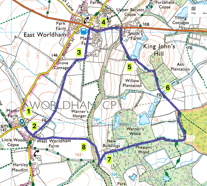
1
With St Nicholas Church behind you, take the road on your left, following the sign towards Hartley Church / Oakhanger. Continue along the quiet country lane until just before it becomes a bridleway.
At this point, look for the red and white arrow and turn left, crossing over the metal stile to carry on your route

2
The path now leads you across a series of open fields and pastures, where you may encounter grazing livestock along the way. You’ll cross several stiles in this stretch.
Follow the wooden fence of a horse pasture to a small tarmac lane.

3
When the footpath meets a tarmac lane, turn right. A little further on, after rounding the corner and pausing to enjoy the lovely views, look for a narrow footpath on your left—it runs between a hedge and a fence. Be sure not to continue straight along the lane ahead, as this leads to a private drive.
The walk then carries on through a couple of horse pastures, with some more stiles to guide you along the way.

4
When the footpath reaches the B3004 in East Worldham, turn right along the road towards Kingsley. You are now following the Hangers Way.
The Hangers Way is a 34 km long-distance trail through East Hampshire, following steep wooded slopes known as “the hangers” and linking Alton with Queen Elizabeth Country Park.
As you head downhill and leave the village, look to your right for a wooden gate beside a tarmac drive and a telegraph post. The walk continues here—simply follow the sign pointing you along the Hangers Way.

5
From this point, stay on the Hangers Way, keeping an eye out as the signage can be a little sparse or tucked away.
After a gentle left turn, you’ll notice three ponds on your left.
Just by the far edge of the third pond, look for a large metal gate alongside a wooden kissing gate—this is where the walk continues.

6
After a few minutes, the grassy footpath divides—take the right-hand fork that slopes downhill, even though there’s no visible waymarker here.
A little further on, after a polytunnel, look for a wooden kissing gate marking the edge of Binswood. Turn right again, just after the gate and keep to the footpath on that side.
This path leads you towards a metal gate. Once through the gate, continue straight ahead. Be aware that this stretch can get very muddy, so good footwear is recommended.

7
Follow the path straight ahead and continue do so when it merges with a country lane. Just after a corner, is where this walk diverges from the Hangers Way.
After an uphill section, look for a waymarker to a wide footpath on the right – this is where the walk carries on through a couple of gates and across some grassy fields.

8
After a short, steep climb the path levels out onto an open field—simply keep heading straight across.
When the bridleway meets a lane, continue straight ahead and then retrace your steps along the familiar route back towards West Worldham.
